Blog

How To Get To Playa Colorado, Nicaragua (2021)

Traveling to Playa Colorado is not difficult, but does take some coordination. There are a few different routes to get there. The main two are:

  1. Fly into Managua, Nicaragua – then take a ~3hr car ride to Hacienda Iguana
  2. Fly into Liberia, Costa Rica – then cross into Nicaragua via car or bus, then catch a ride to Hacienda Iguana

Accessing Playa Colorado

To make a proper decision about how to get yourself to Playa Colorado, it may help to understand how it’s laid out. Because it is within the gates of the larger Hacienda Iguana property, you can’t just stay in the general area.

Playa Colorado (the beach) can be accessed by:

  • Car or on foot from Hacienda Iguanas
  • Boat

If you’re staying at the resort to the north, Rancho Santana, you can walk, bike or drive to Playa Colorado, but it isn’t very close.

If you plan to surf Colorados more than once, your best bet (by far) is to stay within Hacienda Iguana.

Hacienda Iguana

The Hacienda Iguana area is a gated and secured “ranch”.
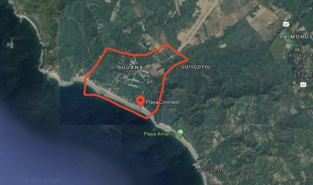
The property is mainly made up of:

  • A 9 hole golf course
  • A handful of 2-4 story condo complexes
  • A few small restaurants and mini-marts
  • Scattered privately owned houses (mostly concentrated by the Play Colorado beach)

If you aren’t staying at the ranch, or don’t know someone who is, it will be difficult for you to get in.

If you’ve locked down a spot inside Hacienda Iguana… getting there is your next challenge.

Getting to Hacienda Iguana from Managua

Your best bet is to arrange a ride from the airport straight to your place in Hacienda Iguana ahead of time. In 2021 the price range was $100-160 USD depending on how big of a car you need. A sedan is on the lower end and a large van is on the higher end.

You should be able to arrange transportation through whoever you booked a place with. AirBnB’s and other accommodations are used to helping people with transport. Make sure you clearly communicate your flight information, number of people, board bag situation, etc.

You’re looking at a 2.5-3hr drive depending on traffic and how aggressive your driver is.
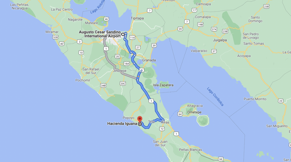
Private car from Managua to Hacienda Iguana is 2.5-3hrs

Alternatively, you can take public transportation (this consists of local buses that are old repurposed American school buses). This will be significantly cheaper but much harder to navigate and much less comfortable. You’ll likely have to do at least 2 bus transfers and depending on your time of arrival, this may require an overnight stay in an intermediary city. Doing all of this with boards increases the inconvenience. Even if you’re looking for an unusual adventure, I’d still recommend saving the public transportation system for another day when…

  • You haven’t already been traveling all day
  • You don’t have boards with you
  • You aren’t going as far

Getting to Hacienda Iguana from Liberia Costa Rica

This path requires a little bit more logistics, but the majority of people I met at Colorados had opted for this route over Managua (mostly because of COVID testing requirements – see next section for details).

Getting to Hacienda Iguanas from Costa Rica requires the following steps:

  1. Fly into Costa Rica
  2. Get a COVID test in Costa Rica (subject to change – check restrictions before traveling)
  3. Get a ride to the border
  4. Go through customs
  5. Get another ride from the border to Hacienda Iguana (about 1.5hrs)

While the drive is shorter, you have to factor in steps 1-4 as well… which ads a fair amount of planning and logistics for you. You’re most likely looking at arranging two different drivers, and a post-landing COVID test (plus waiting for the results).

There are services that will help you arrange this whole process. You should ask your housing contact for help if you’re considering this route. They will be able to advise you on logistics, pricing, etc.

COVID Considerations

You definitely need to plan ahead and be careful about your logistics when it comes to COVID and traveling to Nicaragua. Making a mistake in this aspect of your travel might cost you your trip… here’s a full guide on how to navigate COVID for travel to Nicaragua.
Surf Report Data

Understanding where your surf report data comes from can help you find better waves by improving your ability to:

  1. Understand what the surf report really means
  2. Evaluate how accurate it is (and how much to rely on it)
  3. Make decisions on when and where to surf

Where Does Swell Data Come From?

Data Source: Ocean Buoys

Swell size and period data comes primarily from buoys out at sea.

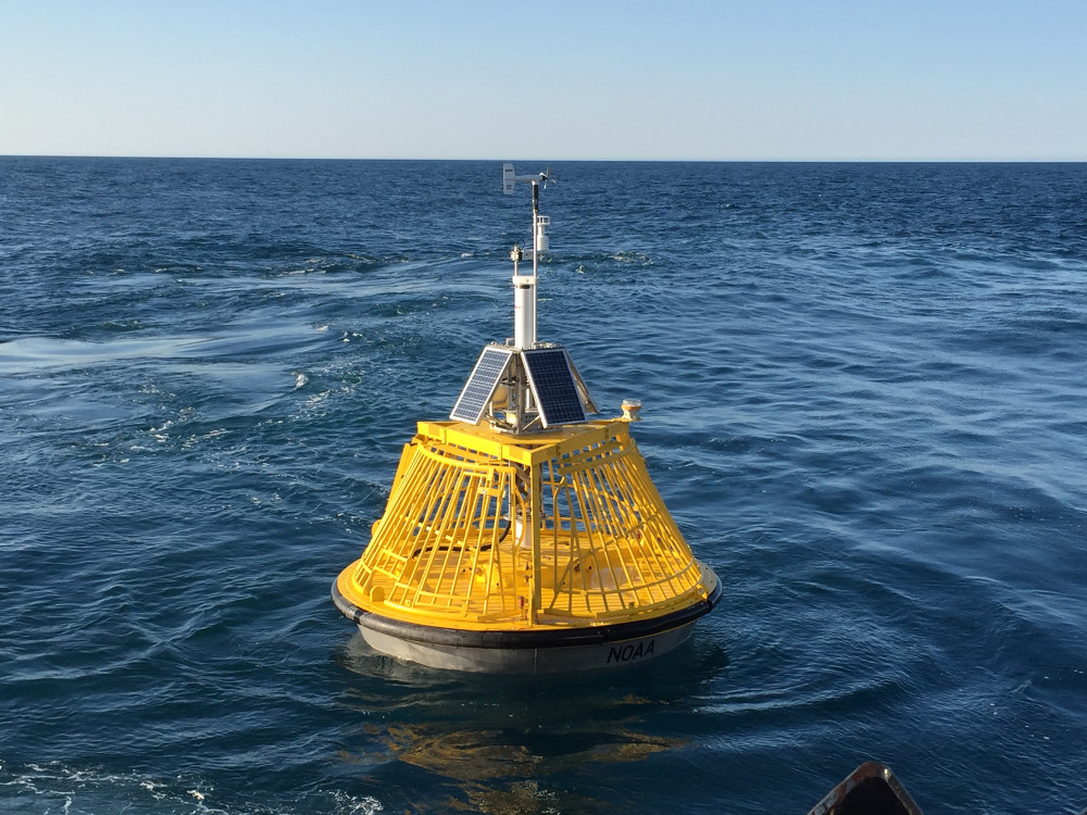
This is what an ocean buoy looks like:

Station 46050 – STONEWALL BANK – 20NM West of Newport, OR

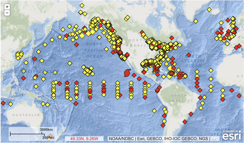
There are hundreds of buoys around the world. A large portion of them are placed and maintained by NOAA – the National Oceanic and Atmospheric Administration. There is a dedicated program for managing the buoys and the data that comes from them – the National Data Buoy Center.

Map of NOAA Buoys

NOAA Buoy Data

How Does A Buoy Measure Swell Height?

Ocean buoys are equipped with various sensors that help them capture data about the sea conditions around them.

The two sensors used for capturing swell height are:

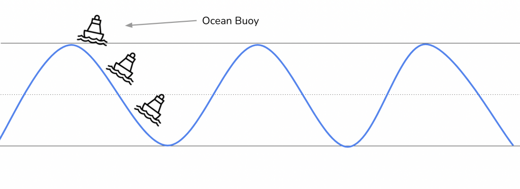
  1. Accelerometers (Most Common) – measure up and down movement as waves roll past them.
  2. Water Pressure Sensor Arrays (Less Common) – measure water pressure as waves move over them.

The movement of the buoy also captures sea surface elevation which can be used to estimate swell height.

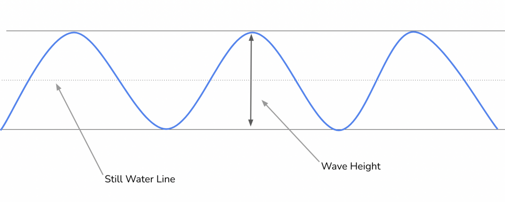
A simplified diagram of ocean swell (waves).
Ocean buoys move up and down as waves pass, measuring the swell height.

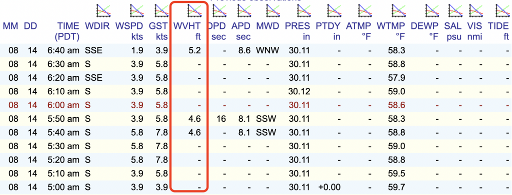
Buoy data comes from NOAA in raw format that looks like this:

As you can see there is much more data than just wave height (WVHT). Main Data Points:

  • Time
  • Wind Speed and Direction
  • Water Temperature
  • Swell
    • Height
    • Period
    • Direction

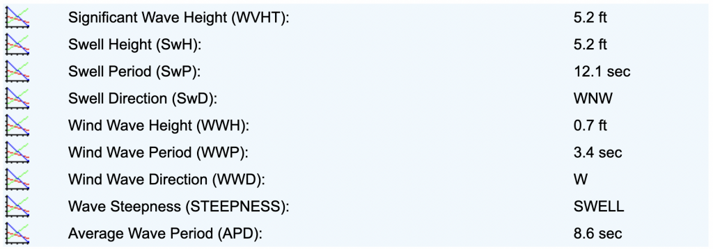
Wave-Related Data

Example of wave data from NOAA buoy.

This data gets pulled in by surf reports and translated into a report that is “surfer friendly”.

Some of this information is just raw data from the most relevant buoy, formatted and visualized in a way that is relevant to surfers.

Surf forecasts, however, are the result of a combination of data points that are evaluated to come up with a prediction of surf conditions for a specific area.

How do surf reports combine data?

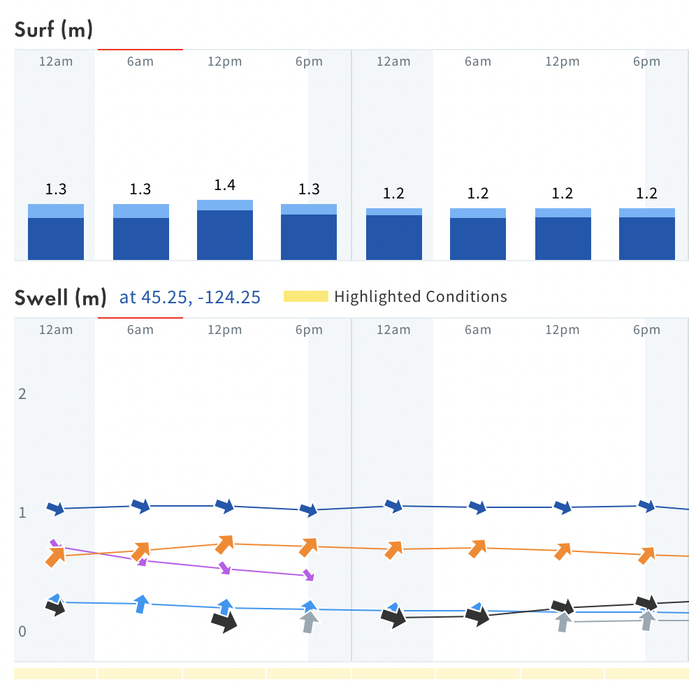
Surfline is famous for its LOLA wave forecast system and is a great example of how websites like surfline turn buoy data into surf reports.

LOLA is a proprietary model created by surfline. It is essential an algorithm that takes in various data points and provides a surf and swell forecast. The main data points it uses are buoy data and bathymetry (ocean floor contours that affect how waves break at different beaches).

The forecasting algorithms of services like Surfline are a bit of a black box. The only information the company reveals is that certain data goes in and a “reliable” surf forecast comes out. It isn’t clear how many buoy data sources they use or how they calculate it… however, I do have some modeling experience as part of what I studied in college (GIS), so I may be able to shed a little more light on this.

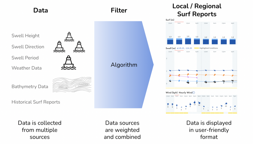
How surf reports like LOLA are generated:

What happens in the algorithm filter?

  • Data is weighted – some data is more important of a contributor to swell height and quality than others.
  • Data is calculated – some calculations are made to estimate the outcome of multiple swell types merging together. Data points like swell height, speed, and changes in conditions over time can feed calculations to extrapolate the life of a swell into the future.
  • Some metrics are converted – some metrics may be converted into surfer-friendly terminology.

The outcome is a surf report that is often as simple as a color and surf size range by the day.

Knowing that there are so many different variables can help in several ways:

  1. Forecasts change – you should view forecasts as dynamic, rather than an accurate prediction of what will come in the next few days. Just like tracking a hurricane, meteorologists may have a good idea of where it will go and how strong it will be, but there are so many variables that things can change at any moment.
  2. Accuracy is different by location – some places like the coasts of the US have a large amount of buoy data to evaluate, while other locations only have a few. So some surf breaks will have more accurate forecasts.
  3. Local factors – there are other local factors that influence surf. A surf report may give you the swell rating, but you also have to take into account tides and wind conditions.

How I use surf reports

I use surf reports as a data point into my own “Filter”. By combining my own local knowledge of surf breaks with a regional forecast, I can usually have a fairly good idea of what breaks in my area will be best.

As a general predictor for swell events. If I know a swell is generating at a particular size and from a particular direction I will change the surf spots I go to check. I know for my region:

  • Certain swell angles make surfing in the northern breaks better
  • Certain swell periods break better on reefs rather than beach breaks
  • Some swell sizes are too big for certain breaks but very good for others

How and when to read buoy data

Welcome To Surf Economics

Welcome to Surf Economics (AKA Stoke-o-nomics) – Please read before continuing…

This website is for surfers who want to increase their stoke.

Definition of “Stoke”: If you don’t know, this website isn’t for you. Go back to trolling YouTube or Facebook and come back after you’ve been bitten by the bug.

I do an economic evaluation of surfing to find ways to increase stoke levels. Then I share them with you here.

The main things I focus on to help you increase your stoke levels are:

  • Surf Quality – Getting more pleasure out of surf sessions
  • Surf Quantity – Fitting more surf time into your life
  • Propensity for Stoke – What? Other stuff that can impact your stoke

Most of us live our lives and make decisions based on stoke-o-nomic principles and the Stoke Level equation:

(Surf Quality * Surf Quantity) / Propensity for Stoke = Stoke Level

Let’s break it down so we can understand why we really surf and find ways to keep the stoke alive.